


Water from the birth of time,
water from the deepest depths of Earth,
from the crests of Age-Old Glaciers,
the waters of our rivers, great and small
have carved out our country.
We are of this place, we are Huron-Wendat, Innu, Cree, Abenaki and all our brothers,
we are from France, from Scotland, Ireland, England, and from farther still.
For 400 years,
water has flowed into our open hands,
hands that will carry Quebec
from now to tomorrow.
–Marie Laberge, 2008
This is a portion of the verse that stands beside the Tourny Fountain, which flows in the middle of a roundabout just outside the provincial parliament buildings in Quebec City.
It perfectly distills the many ways in which water has critically shaped Canada’s history: by sculpting its breathtaking landscapes, by carrying European settlers to its shores, by supporting livelihoods but at times demanding the ultimate price.
These waters have nourished us and devastated us, and yet very few people ever give a second thought to the reminders of that history that lie concealed just below the surface. From shipwrecks dating back hundreds of years to frigid underwater feeding grounds teeming with life, Quebec’s maritime regions conceal numerous natural wonders alongside our country’s very foundations.
They lie there silently, waiting to be discovered by those who choose to seek them out.
Quebec City to Les Escoumins: Precious Waters

Within 30 seconds of looking out over the Saguenay fjord, a beluga whale greets us.
Unique among ocean creatures, its white skin gleams unmistakeably against the crisp blue water. St. Lawrence belugas usually travel in packs, so there may have been others just below the surface swimming together up the fjord to Baie-Sainte-Marguerite, where this endangered species commonly heads to feed.
Saguenay–St. Lawrence National Marine Park, celebrating its 20th anniversary this year, took a rewriting of Canada’s environmental protection measures to establish – an endeavour that was deemed worthwhile to protect rare creatures such as these belugas and their environments.
Several critically important maritime features are found here: the Saguenay fjord itself, which is the southernmost fjord in the northern hemisphere; the beluga feeding and breeding ground at Baie-Sainte-Marguerite; and an underwater shelf just off the shore of the village of Tadoussac, where the sea floor plummets by several hundred feet and marine life is attracted to the swirling food cycle created by the estuary, where fresh river and salt ocean waters combine.
It takes roughly three hours of driving to go from Quebec City through the picturesque hills of Charlevoix to reach the western edge of the fjord by following Route 138, the road that links Quebec’s entire traversable length of the north shore of the St. Lawrence. Once Baie-Sainte-Catherine and the Pointe-Noire Interpretation and Observation Centre are reached from the west, Route 138 has already passed nearly 60 km of shoreline protected by Parks Canada.

Pointe-Noire is a logical first stop for appreciating the park. On top of the spectacular views of the fjord, interpretation panels provide some insight into the feeding patterns of the local sea life. Those travelling with children will also want to pick up the Parks Canada Xplorers booklet here – this is the first of three stops required to complete all of the activities, and there’s a great introduction to geocaching that shouldn’t be missed. An hour is enough to take everything in, and a quick turn right out of the parking lot sends you directly into the line for the free ferry across the fjord into Tadoussac.
Thanks to the shelf on the river floor, Tadoussac is one of the best places for whale-watching anywhere in the world – and for those travelling from central Canada, it also happens to be the closest to home. On our three-hour whale-watching tour, we were able to observe roughly a dozen minke whales, two fin whales (one with a calf), a humpback whale that the locals have named Tic-Tac-Toe – humpbacks are easy to identify as the only species that consistently flashes its highly individualized tail as it dives – and more seals than we could count.
Further up the river at Cap-de-Bon-Désir, a well-timed visit can afford a chance to explore the site’s many tide pools, possibly even as an organized park activity led by a Parks Canada interpreter. The pools are far fuller of life than they seem from a distance. My daughter delighted at the scuds, a type of freshwater shrimp, as they repeatedly wriggled their way out of her hands. Another activity not to be missed is Ocean Encounters, where divers bring whatever sea life they find on the nearby riverbed up to the surface. Staff recreate the river environment in small pools where the creatures like crabs and sea stars are kept comfortable while their unique characteristics and habits are explained before being returned to the river. This is an educational highlight not to be missed.

The northernmost riverside point in the park is the Marine Environment Discovery Centre in Les Escoumins, which acts as the park’s limit being nearly another 40 km from Tadoussac. This location’s primary highlight is its snorkeling and diving centre, which can be enjoyed by those over 14. Younger guests can appreciate the interpretation exhibits and the views from the observation decks.
What stayed with me most about visiting this part of the Côte-Nord is that conservation efforts extend beyond the park. My daughter asked for a straw at dinner in Tadoussac and was told that the restaurants in the area don’t stock them because they too easily end up in the rivers polluting the waters. At the town’s Marine Mammal Interpretation Centre, we learned that the boats of commercial whale-watching tour operators can disrupt the feeding patterns of the very animals they depend on, and so several local businesses have voluntarily joined the Eco-Whale Alliance and choose to have their activities regulated and monitored. These are small steps on their own, but they come together to make a big difference.
Those who have driven from central Canada to the East Coast often will have driven the route along Ontario Highway 401 and Quebec Autoroute 20 to turn south at Rivière-du-Loup many, many times. This path across the north shore adds a day or two to the trip, but it offers a much more scenic and educational journey eastward. The ferry from Les Escoumins to Trois-Pistoles disembarks just 20 minutes east of Rivière-du-Loup, giving the option to continue south from a different angle or carry onward into the Gaspésie with new experiences to take along.
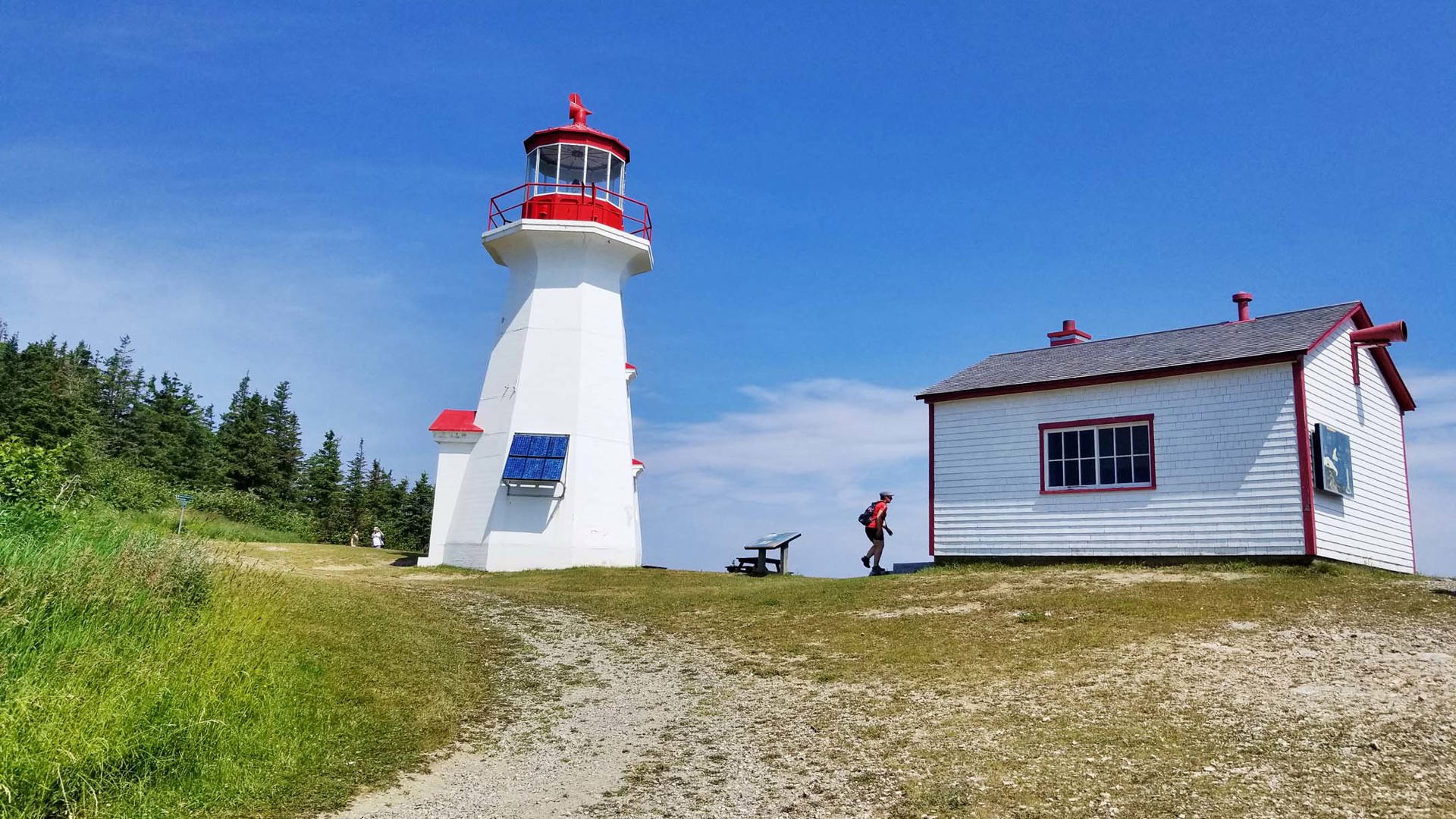
Rimouski to Rivière-au-Renard: The Lighthouse Trail

To call Route 132’s trip around the Gaspé Peninsula the Lighthouse Trail tells only a fraction of the story.
Yes, there are plenty of lighthouses, and they’re historically important and marvellous. But there are also postcard-worthy villages punctuated with church steeples and strung like pearls along the coastline, myriad gastronomical experiences for those willing to search beyond the endless casse-croûtes, and valleys interspersed with cliffs and ancient mountains that seem hung from the sky by towering pines.
Pointe-au-Père Lighthouse National Historic Site in Rimouski is an especially poignant place to stop for a visit as it covers so many different aspects of Canada’s maritime past: the lighthouses that once guided the world’s ships through difficult routes, the warships designed to defend those same waters, and one of the worst maritime disasters in this country’s history.
The latter refers to the sinking of the RMS Empress of Ireland, an ocean liner that was on her 96th voyage along the North Atlantic route between Quebec City and Liverpool when she foundered on May 29, 1914, after being consumed by fog and subsequently rammed by the Norwegian collier SS Storstad. Although the ship submerged completely in just 14 minutes and took 1,012 lives with it, the escalating tensions in Europe that were leading to the First World War caused the disaster to lag in attention and international headlines despite its similarities to the loss of the RMS Titanic just two years earlier.

The wreckage of the Empress of Ireland was a favourite of divers from the time it was rediscovered in 1964 until it was protected as a historic site in 1999, and many of the items recovered during that time are on display today at the museum at Pointe-au-Père Lighthouse. What stands out most to this parent, though, is how well the museum is prepared for its young Xplorer visitors.
My daughter learned about the disaster in a book years ago and asked us to bring her to this place, but once here she had trouble interacting with the profound information presented on interpretation panels. However, she was very happy to listen to Emmy the cat, whose audio guides are scattered throughout the exhibits and make the difficult subject matter much more approachable for children.
Our tour of the HMCS Onondaga was a much bigger hit. This Oberon-class submarine was built in the mid-1960s and is a historic treasure as the first submarine opened to public tours in Canada. (It was followed by the HMCS Ojibwa, which is dry-docked in Port Burwell, Ontario, about two hours west of Toronto). Although it was in service through the Cold War, it never saw active combat. Still, it captures a moment in military time that’s otherwise impossible to experience.

Route 132 holds all sorts of unique surprises. Although it looked interesting from the roadside, we nearly didn’t stop at Le Vieux Moulin – I’m glad we made the U-turn, though, because we ended up with some sweet treats and a half-case of honey wine to bring home. At the Fromagerie du Littoral, halfway between Métis-sur-Mer and Saint-Ulric, cheese curd connoisseurs will want to stop to sample a bag finished with an herby pesto.
If you opt not to add the drive across the north shore to your trip, Exploramer is just off the highway in Sainte-Anne-des-Monts and offers touch pool experiences similar to those at Cap-de-Bon-Désir among other exhibits, albeit in a less authentic environment and for a higher cost.
But most travellers will be happy to sit back in their vehicles – the 2019 Ram 1500 we took along for the ride is about as good a road trip truck as they come – and enjoy the spectacular views.
Forillon National Park: Land’s End

I feel very proud to live in a country that identifies and protects its exceptional natural places. Forillon National Park is a perfect example.
Here, the Appalachian Mountains make their final plunge into the Gulf of St. Lawrence, ending not with a whimper but a mighty roar: towering cliffs, beaches lined with soft sand or gentle round pebbles, wildlife encounters – at one point, we helped a hungry porcupine safely cross our campground road – and historic sites of every description.
We stayed the night in an oTENTik, a permanent structure that’s an ideal solution for transient travellers. With the tent and beds already set up and in place, throw a few extras like linens and food into the car and the wilderness becomes accessible with a minimum of effort.

The highlight of our stay was our hike to Le Bout du Monde, a somewhat hilly but very well-cleared multipurpose trail that passes by rocky coves and ocean vistas before reaching the Cap Gaspé Lighthouse and, after an additional and more challenging 350-metre hike, the Land’s End Lookout. Our efforts were rewarded with spectacular views of the vertical cliffs, along with unusual birds and frolicking seals. It took nearly three hours all told, but it was worth every minute.
On our quest to complete the Parks Canada Xplorers activity booklet, we also went through the Hyman House and Store, Quebec’s only fully preserved World War II shore battery at Fort-Péninsule, and Penouille Beach. We stayed hours longer than we’d intended and wished we’d had many more days to explore.
Percé and Île-Bonaventure: Nature’s Magic

Of all the geological wonders on Quebec’s coastlines, Percé Rock with its dramatic limestone cliffs is undoubtedly the most famous.
And it certainly is a sight to behold. There’s something magical about it that invites contemplation. How has it evolved this way? How did the townspeople react on the day the second arch collapsed dramatically in 1845? And with several hundred tons of rock falling off it every year, how much longer will it last?
But the truth is that once that gazing and contemplating has been done, there’s not much more to it. Visiting the island is dangerous because of the high risk of falling rock. There are plenty of boat tours that sail relatively close to it, but a few minutes later they move on. It’s an unparalleled beauty that can be appreciated but fleetingly.
Most of those same boat tours continue on to Bonaventure Island just a few minutes away, though, and this is where a visit has the potential to get much more interesting.
Those able to manage a moderate hike for a couple of hours must not miss the opportunity to disembark and walk to the island’s eastern shore.

After passing through tranquil forest for nearly an hour, possibly with a couple of wildlife encounters along the way, the first notable indication that something unique is on the horizon is the almighty racket that begins to drift through the trees. Not long afterward, it’s followed by an acrid, powerful stench.
Then, after cresting a final corner, the sea comes into view, along with birds – thousands and thousands of them, covering one end of the coastline to the other. They’re northern gannets, and the colony on Bonaventure Island is one of the largest in the world. At last count, there are more than 150,000 nesting here, and they don’t care a whit about the human visitors that stand mesmerized watching their fascinating behaviours.
With the better part of a day to spare, families can complete a treasure hunt that sends children on a trivia quest through two of the park’s primary trails. At the end, a successful quest ends with them sharing a portion of the pirate’s booty.
The park is very well-equipped – there’s a small restaurant at the dock and a snack bar at the gannet colony, restroom facilities on the hiking trails, and the carefully restored remnants of a former fishing village – and the village of Percé is undergoing some significant improvements with the addition of a waterfront boardwalk and a massive playground. It’s no secret that Percé is a wonderful vacation destination on its own, and that initial glimpse of the rock in a car’s windshield will always make one’s heart leap, whether it’s for the first or the 50th time.
Baie-des-Chaleurs: The Fate of a Nation

Rounding the Gaspé Peninsula toward its southern region brings another coast into view from across the water, this time the northern shore of New Brunswick.
Baie-des-Chaleurs and the Restigouche River that feeds it look placid today, but over 250 years ago they played host to a fierce naval battle that was directly responsible for determining the fate of colonization on this continent.
The outside of the Battle of the Restigouche National Historic Site, established to pay tribute to the battle and protect the lands and waters where it took place, reveals little. A simple pathway leads to the front door of a simple building with an unassuming view over the river. On the lawn, 18 white markers are set out with no clear pattern or purpose.
Through the museum’s displays, though, a dire situation for France’s North American settlers in the late 1750s comes into focus: Quebec City has fallen to British forces, and New France has called for 60 ships with 4,000 men to be sent from Europe to recapture the city.
France is engaged with Britain in the Seven Years’ War at that time, so it can’t spare that volume of resources. It sends what it can: 400 troops and five merchant ships carrying supplies plus a frigate escort, the Machault.

Three of the smaller ships are lost on the way, and the remaining three find their path to Quebec City blocked by a British flotilla and turn to Baie-des-Chaleurs for shelter, where they enlist the help of the local Acadian and Mi'kmaq populations to add 1,500 fighters and numerous small boats to their ranks. The British follow them into the bay and corner them; after an extended battle, the French sink the Machault to prevent its capture and the rest of the fleet falls.
Although the Governor of New France, Pierre de Rigaud de Vaudreuil de Cavagnial, said at the time that “the sight of a French flag would have brought about the surrender of Quebec City,” the realization that its promised support lay at the bottom of the Restigouche River instead led New France to surrender.
The historic site’s museum is full of hundreds of artifacts pulled from the wreckage of the Machault by Parks Canada, including an entire massive section of its hull, spanning two full floors. The Xplorers activity book encourages young visitors to consider what life might have been like for the sailors on board, complete with a scavenger hunt for troublemaking rats. Outside, a map marks where five shipwrecks still lie below the surface of the bay, wearing the scars of this country’s foundations.
And those markers on the lawn? They show the actual size of the Machault relative to the river, an excellent tool for putting the scale of the events that took place here into perspective.

Every wave that crashes onto Quebec’s shore connects us with the challenges of our past, the beauty of our present, and the importance of preserving these things for our future. The waters of our rivers, great and small, have carved out our country; may they carry Quebec, and Canada, from now to tomorrow.

You may also like